Green Infrastructure Center, Inc.
GIC maps natural assets to create green infrastructure plans and green prints.

Virginia Resilient Coastal Forests Benefits

Click to enlarge
Coastal forests are important ecological, historical and cultural habitat that are imperiled by a wide range of threats that can impact their abundance, distribution, composition and intactness. Coastal forests are at risk from unprecedented challenges such as sea-level rise and climate change, but many of the U.S.’s coastal areas are experiencing high urban growth rates leading to forest clearing to make room for new housing and industry. Weather-related threats such as hurricanes, flooding and wildlife are increasing in intensity and frequency as global temperatures increase. Increasing global temperatures also influence the distribution and life cycles of plants, animals, pests and diseases causing unforeseen impacts to coastal forest quality. Even some widespread climate solutions to address greenhouse gas emissions, such as development of utility-scale solar energy, may conflict with coastal forests as land is sought for new solar farms.
The pressures facing coastal forests make it imperative that federal, state and local governments, nonprofits, universities, businesses, forest landowners and community members be informed about what is at stake and what could be lost
This pilot study was designed to create a landscape-scale conservation planning process unique to coastal forests of the southeast United States. The pilot study includes an inventory of coastal forest resources and assets, an analysis of the benefits these forests provide, an evaluation of the various threats and their level of risk to coastal forests, engagement of local and state stakeholders about these threats, prioritization of existing forests and the development of management strategies to mitigate or adapt to future impacts.
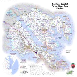
The study area for Virginia is composed of 6 counties (Gloucester, James City, King and Queen, Mathews, New Kent, and York Counties) either entirely or partially and 8 towns or cities (Bethel Manor, Gloucester Courthouse, Gloucester Point, Gwynn, Mathews, Poquoson, Williamsburg and Yorktown) within the lower watershed of the York River. The study area boundary was chosen by staff with the Virginia Department of Forestry and contains a mix of rural, suburban and urban land uses. The counties and towns north of the York River are predominantly rural in character, while the counties, towns and cities south of the York River experience higher density and more urban growth patterns. A mix of land uses and urban growth patterns was chosen to evaluate different development pressures on coastal forests. This mix is intended to demonstrate the different opportunities and challenges to coastal forests and requires the engagement of diverse stakeholders and community types
Learn more on our Resilient Coastal Forests page
Back to Resources